RAS EL HEKMA / THE FIELD ATLAS
The plans, read closely.
City to precinct to home. Explore the drawings, follow the water, and compare the editions.
The city masterplan and published precinct framework
Ras El Hekma city
Explore Modon’s city drawing, its published precinct divisions and the three marina locations. Each view keeps its own source geometry.
Detailed intended-development drawing. The precinct framework is a separate published view.
Two editions, two views.
Separate drawings; no geographic alignment or construction change is inferred.
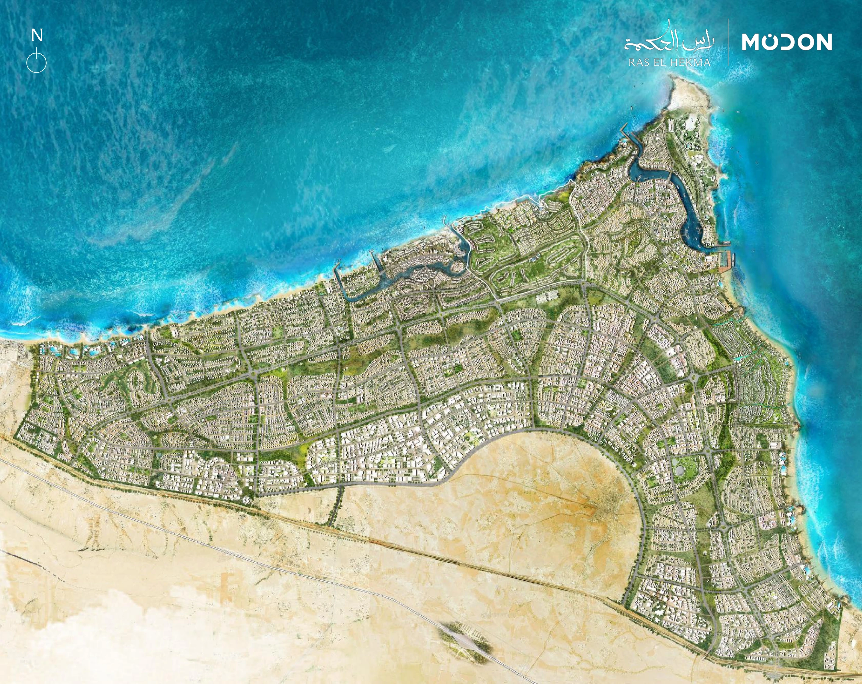
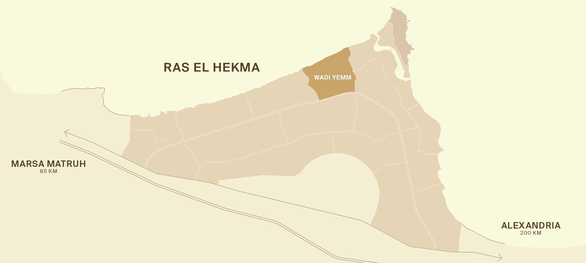
Explore the components.
Source positions are specific to each edition. Selecting a component opens its supporting view where available.
No matching components. Try another name or layer.
01 / READ THE SCALE
Land area and coastline
tell different stories.
Compare the published figures on the same units. Wadi Yemm is about 5.3% of the city’s reported area, but its reported coastline is about 10.2% of the city figure.
44 km coastline · June toolkit p9
4.5 km coastline · toolkit p22
4.8 km beachfront · April media summary
A large land area does not describe the water relationship of an individual home. Read its collection, terrain and usable shore separately.
THE SOURCE, UP CLOSE
Look inside the drawing.
Expand the selected source details. Captions keep the edition, page and intended-development status visible.
02 / READ THE WATER
One waterfront.
Six different edges.
Choose a type of shoreline to see it clearly. Use “Close up” to inspect its shape on the same plan. A sea view does not always mean a beach below the home.
Guide lines follow the water’s edge in this June plan. The shoreline types come from Modon’s published key. The points where one type changes to another are approximate. © Modon · planned design.
Beach
1.5 km beach length in the toolkitA sandy coast. Ask how you reach the beach and who is allowed to use it.
Different measures, not three lengths to add. These are planned descriptions, not present access or safety checks.
THE BOULEVARD RESIDENTS’ CLUB
A place to work,
meet and exercise.
This is the planned Boulevard residents’ club. See the spaces for work, families, meeting friends and exercise. It is separate from the golf and country clubs.
Work without leaving the collection.
The plan has a shared work area and separate meeting rooms. An arrival area beside the meeting rooms is also shown.
Source room labels · 06 shared work area · 13 meeting rooms / arrival area
The plan places the club in Building 20B, overlooking the park. Ask who can use it, when it will open and what membership or bookings will cost.
Original layout © Modon. Guide boxes group the programme for reading; they are not architectural room boundaries or completed facilities.
THE SOURCE, UP CLOSE
Look inside the drawing.
Expand the selected source details. Captions keep the edition, page and intended-development status visible.
03 / READ THE HOME
The Crest, floor by floor.
Use the actual Palm Hills brochure drawings to distinguish the living level, four-bedroom floor and optional penthouse.
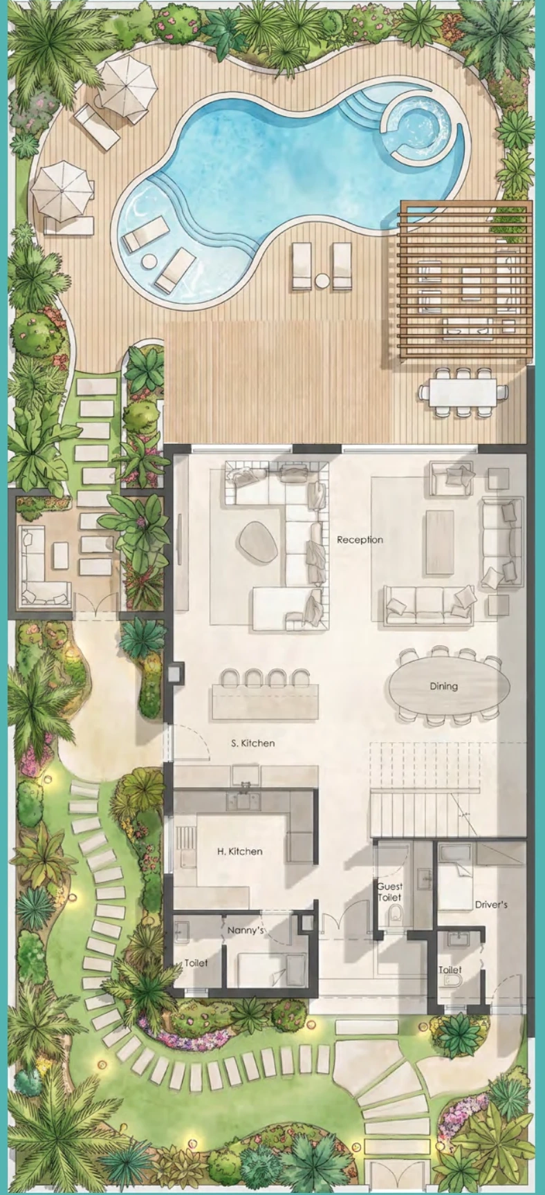
GROUND FLOOR · BROCHURE P6
Living, dining and service spaces
Separate soft and hard kitchens, reception and dining, nanny’s and driver’s rooms appear in the drawing. The illustrated pool, landscaping and pergolas are not automatically included.
Three area definitions.
Brochure p5. Separate measures; no combined “total living area” is calculated. Actual plots and elevations can vary.
Original drawings © Palm Hills · supplied PH-RH 5th Row brochure, p6–8. Generic typology only; no private offer or unit availability is reproduced.
THE SOURCE, UP CLOSE
Look inside the drawing.
Expand the selected source details. Captions keep the edition, page and intended-development status visible.
THE CITY, READ CLOSELY
Go beyond the masterplan.
Original guides that turn the drawing
into questions you can use.
The city in layers
Understand the precinct framework, planned infrastructure and scale.
Open the field guide ↗02Four ways to live in Wadi Yemm
Beach Plaza, Boulevard, Wadi East/West and Waterfront Residences.
Open the field guide ↗03Hacienda, edition by edition
Coastal villas, lagoons, the southern extension and the July plan.
Open the field guide ↗04What “waterfront” really means
Beach, cliff, canal and lagoon are different settings.
Open the field guide ↗05The address around the city
Keep Ogami, The Med and the other Hacienda names straight.
Open the field guide ↗How to read these maps.
The developer drawings retain their actual geometry. Our labels, selected feature traces, comparisons and editorial readings add context. Traces use the source image’s coordinates; they do not establish surveyed parcels, navigable routes or completed facilities.
Every edition remains separate. Generic pages from the supplied publications are used with source records and credits. Private chats, contacts, offers and sales inventory are excluded.
Explore the evidence deskAll 50 readings, in one place.
These are the same guide readings shown beside the drawings. Open a place to read them in order.
Ras El Hekma city · 8 readings
- Wadi Yemm
- The northern opening precinct named on Modon’s current city diagram. Its 9 km² toolkit figure is precinct scale, not the whole city.
Check: Use the collection-specific guide and delivery schedule.
Planned · developer material · source page 20,22; current Modon overview · Source record online ↗ - Other precincts
- The current Modon overview leaves the other internal divisions unnamed. The public description gives 17 precincts; June toolkit page 10 uses 17+ precincts & free zone.
Check: A name or launch needs dated evidence; no arbitrary quadrant IDs are assigned.
Planned · developer material · source page 10 · Source record online ↗ - Three marinas & cruise terminal
- The city toolkit proposes one international marina, two domestic marinas and one cruise terminal, with 1,800+ total boat berths on page 13. This marker describes the city-wide programme, not one facility location.
Check: Check customs, berth availability and operator evidence for the specific marina.
Planned · developer material · source page 13 · Source record online ↗ - New international airport
- The proposed city airport appears in the toolkit’s future connectivity programme. Published travel-time claims depend on future infrastructure. This is a programme marker without a surveyed airport position.
Check: Use a booked flight and a confirmed existing arrival airport today.
Planned · developer material · source page 11 · Source record online ↗ - Rapid transit network
- Rapid transit is one of the planned city components. The diagram does not plot a confirmed track, station list, timetable or fare.
Check: Do not plan a current journey around the masterplan network.
Planned · developer material · source page 14 · Source record online ↗ - Central business district
- The toolkit includes a central business district and office-space programme. Marker position is schematic: it does not identify a registered business-district parcel.
Check: Ask which employers, buildings and services are actually operating.
Planned · developer material · source page 15 · Source record online ↗ - Private-sector free zone
- A free zone is included as a city component. Its label does not establish parcel boundaries or individual legal/tax entitlements. Position is illustrative.
Check: Verify the applicable authority and formal rules for your particular activity.
Planned · developer material · source page 16 · Source record online ↗ - Education & health programme
- Toolkit page 10 proposes education and health facilities including 310 schools, two universities and eight hospitals. These are city-scale planning figures. Position is illustrative.
Check: Identify an operating provider and its services, rather than relying on capacity targets.
Planned · developer material · source page 10 · Source record online ↗
Wadi Yemm · 27 readings
- The Boulevard
- The central dining, retail and entertainment spine. The toolkit describes 1.3 km of boulevard and a residential collection continuing inland from Beach Plaza.
Check: Which outlets and building amenities arrive with your phase?
Planned · developer material · source page 23,25,43–45 · Source record online ↗ - Beach promenade
- A proposed 1.6 km activated beachfront promenade. It is a different measure from the precinct’s whole coastline.
Check: Which stretch is accessible from the home, and when?
Planned · developer material · source page 23,25 · Source record online ↗ - Beach & amphitheatre
- An entertainment and beach component at the north-central frontage. The kit presents a planned setting rather than an events calendar.
Check: Confirm the location, season and access policy separately.
Planned · developer material · source page 23 · Source record online ↗ - Coastal park / natural reserve
- A green coastal component shown in the northeastern part of the drawing. “Natural reserve” is the plan’s label, not an independently verified protected-area designation.
Check: What habitat, visitor access and maintenance provisions are committed?
Planned · developer material · source page 23 · Source record online ↗ - Multi-faith zone & clinic area
- A planned service cluster near the Boulevard. A clinic label does not identify a licensed operating clinic or emergency capability.
Check: Who will operate it, what services will it provide, and from which date?
Planned · developer material · source page 23 · Source record online ↗ - Western golf course
- One of the two proposed 18-hole championship golf courses. The west side also contains canal-facing residential and hospitality components.
Check: What is included in ownership, and what needs separate membership?
Planned · developer material · source page 23 · Source record online ↗ - Eastern golf course
- The second proposed 18-hole course, extending toward the southeastern side of the precinct drawing.
Check: Ask for opening evidence and membership terms, not only proximity.
Planned · developer material · source page 23 · Source record online ↗ - Golf clubhouse
- A clubhouse component next to the western golf landscape. It belongs to the precinct leisure plan.
Check: Which facilities and fees apply to your residential collection?
Planned · developer material · source page 23 · Source record online ↗ - Equestrian centre
- An equestrian component near the eastern golf landscape. The kit gives no verified opening date.
Check: Check whether residents, visitors and children have different access rules.
Planned · developer material · source page 23 · Source record online ↗ - Western hospitality
- A hospitality marker on the canal/western waterfront side. The kit shows six hospitality assets across Wadi Yemm, around 1,000 keys in total.
Check: This generic marker is not assigned to Montage or Nammos without a labelled plan.
Planned · developer material · source page 22–23 · Source record online ↗ - Beachfront hospitality
- Several hotel markers occupy the central and eastern beach frontage. These are location categories in the plan, not confirmed operating hotels.
Check: Which named operator, exact parcel and opening date apply?
Planned · developer material · source page 23 · Source record online ↗ - Eastern beach hospitality
- Another planned hospitality position along the beach frontage. Operator announcements and generic markers cannot be matched by visual proximity alone.
Check: Request the operator’s dated location plan.
Planned · developer material · source page 23 · Source record online ↗ - Park-side hospitality
- Hospitality appears beside the coastal park in the component drawing. The six-asset count applies to the precinct as a whole.
Check: Check guest/resident access across the hotel and park.
Planned · developer material · source page 23 · Source record online ↗ - Inland hospitality
- The plan also includes a hospitality marker away from the immediate shoreline. “Within Wadi Yemm” does not automatically mean beachfront.
Check: Ask for the actual entrance-to-beach connection.
Planned · developer material · source page 23 · Source record online ↗ - Western branded residences
- Branded-residence markers are distributed across canal, beachfront and eastern areas. A generic marker is not a separate precinct.
Check: Which operator agreement, services and recurring fees attach to the unit?
Planned · developer material · source page 23 · Source record online ↗ - Beachfront branded residences
- A residential category associated with planned hospitality assets. Brand announcements need their own dated evidence.
Check: Obtain the branded-residence service schedule for the actual building.
Planned · developer material · source page 23 · Source record online ↗ - Sports & leisure centre
- A sports/leisure component inland from the beach frontage. The toolkit separately gives a 31,000 m² sports club figure.
Check: Which parts open with your phase and require membership?
Planned · developer material · source page 23,25 · Source record online ↗ - Lighthouse
- An iconic lighthouse is marked near the western coastal edge. A visual landmark in the masterplan, not a currently visitable attraction confirmed here.
Check: Check completion and public-access evidence before planning a visit.
Planned · developer material · source page 23 · Source record online ↗ - Country club
- A country-club component between inland hospitality and golf. Its inclusion in the plan does not establish resident entitlement.
Check: Request the membership and guest policy.
Planned · developer material · source page 23 · Source record online ↗ - Coastal lagoons
- The toolkit describes 25,000 m² of natural/swimmable lagoons and distinguishes these from other shoreline conditions.
Check: Confirm how the published terminology applies to the exact shore and unit.
Planned · developer material · source page 23–25 · Source record online ↗ - Water sports
- A water-sports component on the western canal/waterfront side. The icon indicates intended use.
Check: Check the operator, safety arrangements and permitted activities.
Planned · developer material · source page 23 · Source record online ↗ - Beach Plaza
- The seafront apartment community described in pages 28–29. The kit places it near the Boulevard, promenade, amphitheatre and proposed sports facilities.
Check: Compare the specific building, terrace, kitchen specification and amenity rights.
Planned · developer material · source page 28 · Source record online ↗ - Wadi East & West
- Gated single-family-home communities. Pages 52–53 describe villas/townhouses, approximately 750 m from the sea, with lagoon, green-spine and daily-retail proposals. This is a category marker, not a combined surveyed parcel.
Check: Confirm your particular plot’s walking route, lagoon allocation and gate.
Planned · developer material · source page 52 · Source record online ↗ - Waterfront Residences
- The factsheet places this collection on western Wadi Yemm, between golf, canal and waterfront: 248 apartments, 14 duplexes and 21 townhouses. The guide marks a representative position using that locator, without inferring its parcel.
Check: Resolve the Waterfront/Waterside naming and request the collection’s plot plan.
Planned · developer material · source page 3 · Source record online ↗ - Yemm Views
- The later concept labels this residential setting beside the natural-reserve frontage. The June component legend does not give this collection name.
Check: Request the current collection plan, specification and release evidence.
Planned · September concept label · source page 3 · Source record online ↗ - Yemm Fairways
- The September concept places this label among inland homes beside the golf landscape. No collection specification or release schedule is supplied by this legend.
Check: Request the current collection plan, specification and release evidence.
Planned · September concept label · source page 3 · Source record online ↗ - Yemm Links Villas
- A named villa component in the September concept, adjacent to the golf landscape in this viewpoint. This label is not evidence of current sales availability.
Check: Request the current collection plan, specification and release evidence.
Planned · September concept label · source page 3 · Source record online ↗
Hacienda Ras El Hekma · 15 readings
- Beach villas
- The labelled Miran/OBMI brochure plan shows villas following the northern coastline. Villa rows and visible sea views are separate questions.
Check: Check terrain, row, elevation and any intervening buildings.
Planned · developer material · source page 77 · Source record online ↗ - Beach clubs
- Beach-club labels sit along the northern beach edge in the concept plan. Their presence does not establish current entry or booking.
Check: Which club, which operator and which owner/guest access policy?
Planned · developer material · source page 77 · Source record online ↗ - Beach hotel · 100 keys
- The western concept-plan hotel is labelled 100 keys. This is a plan label, not a verified hotel inventory or opening announcement.
Check: Confirm the current hotel design and operator separately.
Planned · developer material · source page 77 · Source record online ↗ - Lagoon villas
- Residential clusters curl around the inland water network. The plan distinguishes lagoon villas from beach villas.
Check: Check the exact water frontage, permitted use and maintenance charges.
Planned · developer material · source page 77 · Source record online ↗ - Chalets
- Chalets are labelled in more than one area of the concept plan. A product name alone does not determine a view or beach distance.
Check: Use a unit-specific pin and floor, rather than a generic product rendering.
Planned · developer material · source page 77 · Source record online ↗ - Townhouses
- Townhouse areas appear inland and on the eastern side. The guide highlights a representative location in this source edition.
Check: Request the current phase plan and plot schedule.
Planned · developer material · source page 77 · Source record online ↗ - Apartments
- Apartment labels are distributed along the western edge and southern extension. The concept plan shows a mix of building and villa forms.
Check: Check building height, floor, lifts, parking and outdoor-space entitlement.
Planned · developer material · source page 77 · Source record online ↗ - Crystal lagoon
- A central-southern water feature is explicitly labelled Crystal Lagoon in the brochure plan. That label is distinct from direct Mediterranean frontage.
Check: Which lagoons are swimmable, and when are they scheduled to operate?
Planned · developer material · source page 77 · Source record online ↗ - Community areas
- Several areas are labelled community area. They describe intended shared places; no detailed membership or operating schedule is supplied.
Check: Ask for the specific amenities and entitlement attached to your phase.
Planned · developer material · source page 77 · Source record online ↗ - Funicular
- A funicular is labelled toward the southwestern part of the main coastal band in the concept edition.
Check: Confirm whether it remains in the current design and who can use it.
Planned · developer material · source page 77 · Source record online ↗ - Village · retail & dining
- The southern extension contains a village and retail/F&B labels alongside lagoon water. These are intended uses, not a present outlet list.
Check: Ask which services open with the homes and their year-round hours.
Planned · developer material · source page 77 · Source record online ↗ - Southern hotels · 400-key labels
- The concept drawing has two separate hotel callouts labelled 400 keys near its southern extension. No combined operating capacity is claimed here.
Check: Obtain a revised hotel schedule and named operators.
Planned · developer material · source page 77 · Source record online ↗ - Sports, water park & Top Golf
- These recreation labels appear together in the southern extension of the concept plan. A Top Golf label is not evidence of a confirmed brand/operator agreement.
Check: Check the current programme, operator, access and delivery phase.
Planned · developer material · source page 77 · Source record online ↗ - Planned entrances
- The concept edition labels a main and two secondary entrances. Diagram positions must not be used as driving directions.
Check: Get a live arrival-gate pin for your appointment.
Planned · developer material · source page 77 · Source record online ↗ - July plan: version check
- The supplied July image has north orientation but no amenity legend or scale. Its three arrows and faded areas are unexplained. We preserve the image separately and do not treat them as release phases.
Check: Ask for the dated legend and relationship to your current contract plan.
Planned · developer material · source page 1 · Source record online ↗