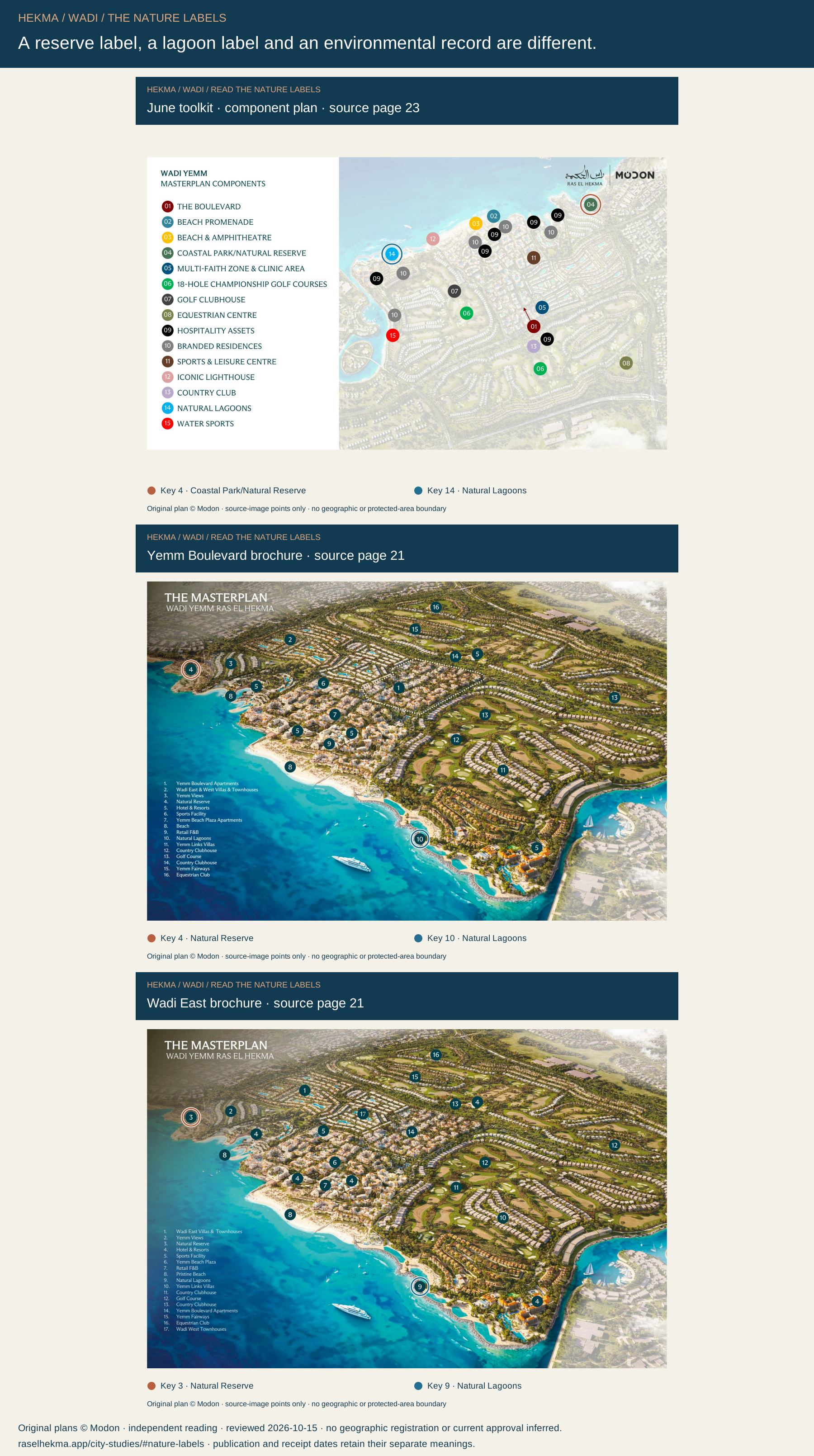
Separate reserve and lagoon labels.
The source drawings distinguish these two proposed components. Neither name establishes current public access or a legal boundary.

RAS EL HEKMA / GROUND, SEA & ENVIRONMENT
A masterplan shows intended development. Ground investigations, marine surveys and environmental records answer other questions. Read them together without turning a study into an approval or a plan label into a protected-area boundary.
Reviewed 2026-10-15 · five evidence readings · three complete Modon source drawings
The source drawings distinguish these two proposed components. Neither name establishes current public access or a legal boundary.
The available accounts describe ground and marine investigations. The guide has not verified their measured results for a particular home.
The 2024 government report records an assessment being started. An older proposed-reserve map remains a historical record.
THREE SOURCE DRAWINGS / TWO DIFFERENT COMPONENTS
Compare the reserve and lagoon labels together, or focus on either original numbered circle. Each edition uses its own drawing coordinates. The full artwork is retained.
June component plan. Complete drawing; both names highlighted.
June toolkit · component plan · Edition month 2026-06.
A proposed landscape component in this drawing. The label alone does not establish a current government designation or its boundary.
A separate water-area label in this drawing. Swimming rights, water management and current access need their own evidence.
These numbers belong to this drawing’s legend. They are not city precinct IDs. Changing the source edition does not establish a land-use change or a development sequence.
Rings mark source-image points. There is no geographic registration, surveyed boundary, borehole map, habitat map or current protected-area designation added here. Page scrolling works normally; there is no dragging or wheel capture.
| Source drawing | Reserve label / key | Lagoon label / key | Date context |
|---|---|---|---|
| June toolkit · component planSource page 23 | 4 Coastal Park/Natural Reserve | 14 Natural Lagoons | Edition month 2026-06 |
| Yemm Boulevard brochureSource page 21 | 4 Natural Reserve | 10 Natural Lagoons | Received 2026-10-02; publication day unknown |
| Wadi East brochureSource page 21 | 3 Natural Reserve | 9 Natural Lagoons | Received 2026-10-02; publication day unknown |
THE EVIDENCE / ITS SCALE / ITS LIMITS
A ministry activity report, a contractor account, a consultant portfolio, an old national proposal and a development drawing should each be read for what they establish.
Government activity report
Egyptian Environmental Affairs Agency · 2024 report
Report year; no individual start day
EEAA’s 2024 report records the start of a strategic environmental assessment for Ras El Hekma.
البدء فى التقييم البيئى الاستراتيجى لمشروع رأس الحكمة.English reading: Starting the strategic environmental assessment for the Ras El Hekma project.
This entry does not provide the final assessment, approval decision, attached conditions or a precinct boundary.
Source publication dates and review dates are separate. A reported scope or assignment period does not certify completion.
Contractor-published project account
Horema · Date unverified
Publication and fieldwork dates unverified
Horema names Modon as client and Dar as consultant. Its Ras El Hekma account describes drilling, groundwater monitoring, geophysical investigation, laboratory testing and reports prepared by development parcel.
The guide has not verified the borehole locations, measured ground results, completed scope or recommendations for any particular home.
Source publication dates and review dates are separate. A reported scope or assignment period does not certify completion.
Consultant-published assignment
Middle East EnviroTech · 2024–2025
Assignment period printed in the portfolio
The consultancy lists a Ras El Hekma environmental profile and marine-survey assignment for Modon Development Egypt. Its scope covers seabed and ocean data, marine communities and sensitivity mapping.
The portfolio is not the survey report or an approval certificate. It does not establish habitat locations, measured water quality or safe swimming conditions for a beach.
Source publication dates and review dates are separate. A reported scope or assignment period does not certify completion.
Historical proposed-area record
Egyptian Environmental Affairs Agency · Map labelled through 2005
Map time label; source publication day unknown
A historical EEAA biodiversity map places Ras El Hekma in its future-reserves table, under key 7. Its caption refers to declared and future reserves through 2005.
This is not evidence of a current designation, a current protected-area boundary or a match to Wadi’s Natural Reserve label. PDF creation and website upload dates do not update the old map.
Source publication dates and review dates are separate. A reported scope or assignment period does not certify completion.
Proposed components on source drawings
Modon · supplied plans · June toolkit and two brochures received 2 October 2026
Edition month and attachment receipt; not opening dates
Coastal Park/Natural Reserve and Natural Lagoons have separate markers in June. The two October brochure copies also distinguish Natural Reserve from Natural Lagoons, with different legend numbers.
The labels do not establish legal status, water management, swimming rights or public entry. Similar wording does not connect them to the historical national proposal.
Source publication dates and review dates are separate. A reported scope or assignment period does not certify completion.
ONE ACTUAL SITE / ONE SET OF ANSWERS
These questions help organise a discussion with the developer and the professionals reviewing the site. They do not confirm that a particular document, approval or service exists.
Which exact site, drawing revision and home reference do these documents cover?
What are the fieldwork dates, report date, approval date and latest revision?
Which factual ground records and signed design recommendations apply to this parcel?
What current groundwater, drainage and water-management information applies to the building or landscape?
Which survey footprint, measured findings and marine conditions apply to this shoreline?
Which current environmental decision and site-specific conditions can be identified?
Is the name a proposed landscape component, a historical proposal or a current official designation?
Who may enter or use the park, lagoon or shoreline, under which current terms?
Original plans © Modon. The saved reader includes the complete source frames, all written readings, map controls and four exports. Wider guide and source links need internet. Dates and unresolved questions remain part of your saved copy.