
Above the model horizon
RAS EL HEKMA GUIDE · SUN & DAYLIGHT
The same terrace.
A different season.
See how the Sun moves through the sky at Ras El Hekma. Change the date and time, then choose a direction for a terrace. Use it to ask better questions about the home you are considering.
2026 educational model at the geographic cape reference · reviewed 13 October 2026 · no actual home selected
01 / DATE, TIME & DIRECTION
Follow the light.
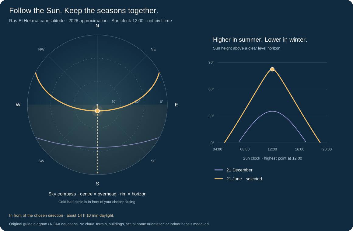
The sky view and height chart use the same date and time. The circle is a view of the sky, not a property map.
This is a Sun clock, not the clock in Egypt. Here, 12:00 is when the model Sun is highest. Civil clock time and daylight saving are not calculated.
Facing is your input, not a measured home direction. Ask the developer for the exact-home plan and a true-north arrow. A sea view does not identify a compass bearing.
South · from true north
Clear level horizon assumption
South · your model input
The link includes your date, Sun clock and chosen facing. No personal details or prices are entered.
02 / A FULL YEAR OF MODEL READINGS
Longer days.
Higher Sun.
The table uses the 15th of each month. It is not a monthly average. The complete CSV has all 365 days in 2026.
| Date | Daylight | Noon height | Rise direction | Set direction |
|---|---|---|---|---|
| 15 January | about 10 h 20 min | 37.5° | 115° · South-east | 245° · South-west |
| 15 February | about 11 h 05 min | 45.8° | 105° · East | 255° · West |
| 15 March | about 11 h 55 min | 56.3° | 92° · East | 268° · West |
| 15 April | about 12 h 55 min | 68.2° | 78° · East | 282° · West |
| 15 May | about 13 h 45 min | 77.4° | 67° · North-east | 293° · North-west |
| 15 June | about 14 h 10 min | 82.0° | 62° · North-east | 298° · North-west |
| 15 July | about 14 h 00 min | 80.4° | 64° · North-east | 296° · North-west |
| 15 August | about 13 h 20 min | 73.1° | 73° · East | 287° · West |
| 15 September | about 12 h 25 min | 62.1° | 86° · East | 274° · West |
| 15 October | about 11 h 30 min | 50.5° | 99° · East | 261° · West |
| 15 November | about 10 h 35 min | 40.4° | 111° · East | 249° · West |
| 15 December | about 10 h 10 min | 35.5° | 117° · South-east | 243° · South-west |
Daylight is rounded to the nearest five minutes in this table. CSVs retain calculation precision for checking the arithmetic; this is not a promise of that accuracy. Directions are degrees clockwise from true north.
03 / THE MODEL & THE HOME ARE DIFFERENT QUESTIONS
Four checks.
One exact home.
Direction
Ask which way the main terrace and windows face, using the true-north arrow on the exact-home drawing.
Obstructions
Ask what stands in front of the windows: other buildings, upper balconies, deep overhangs, walls and trees.
Shade study
Ask for a Sun-and-shade study of the actual home, with the date, time, building height and surrounding layout shown.
Running costs
Ask for the installed cooling system, service charges and measured or properly modelled energy use. This Sun diagram cannot calculate bills.
Read the brochure’s comfort intentions
Page 24 of the supplied Boulevard brochure describes orientation, shading, materials and connected green spaces as part of the city’s comfort design. It also states a LEED Gold design standard and makes general cost and long-term-value claims.
These are design and marketing statements. This reader does not establish a certificate, a measured temperature reduction, lower bills or higher investment returns. Ask for the applicable building certificate and exact-home evidence. Read the dated source note ↗.
READING METHOD & SAVED COPY
What this model calculates
NOAA fractional-year solar declination, held at the date’s noon approximation. Positions use local apparent solar time. Geometric Sun-centre elevation; daylight uses a -0.833 degree horizon convention. Clear level horizon; no buildings, terrain, clouds or thermal model. The latitude is the accepted cape reference, 31.24704° N. Longitude 27.85414° E identifies that reference; it is not used to convert to civil time.
The sky plot is a polar view: compass direction sets the angle, and Sun height sets the distance from the centre. The height chart runs from 04:00 to 20:00 on the Sun clock. Below-horizon parts stay off both paths. Noon height uses geometric Sun-centre elevation. Daylight uses the conventional −0.833° sunrise/set horizon allowance; cloud, haze, local obstructions and atmospheric conditions can change what you see.
The highlighted half-circle only compares directions. No window area, building geometry, direct-sun duration, indoor temperature, thermal comfort, cooling demand or radiation intensity is calculated.
NOAA’s equation sheet supplies an approximation; its calculator documentation notes atmospheric limits and that its service is no longer maintained. No minute-level accuracy or certification is claimed here.
Original guide software and diagrams, with NOAA formula credit and calculation limits. No external API is called by this reader.
THE GEOGRAPHIC LANDSCAPE
Read the height behind the coast.
Explore the historical land-height map and move a section across the cape. Keep this broad landscape model separate from present ground levels and exact-home views.
Explore terrain and height sections ↗